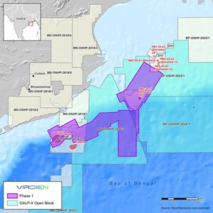
(WO) — Viridien has launched a new regional multi-client seismic data initiative aimed at improving exploration insights across India’s offshore basins, starting with a major reimaging program in the Mahanadi basin along the country’s east coast.

Map: Viridien
The first phase of the project will reimage and merge approximately 9,000 sq km of existing 3D seismic data across the offshore basin to deliver improved subsurface imaging for exploration activities.
Initial fast-track results from the program are expected by June 2026, with the full dataset scheduled for release by the end of 2026, according to the company.
The project is designed to enhance imaging quality across areas with proven petroleum systems as well as deeper-water sections of the basin, where exploration has been limited due to poor imaging quality in legacy seismic datasets.
Viridien plans to apply advanced processing technologies, including time-lag full-waveform inversion (TLFWI) and least-squares pre-stack depth migration (LSPSDM), to produce a unified, high-resolution 3D dataset covering the basin.
Dechun Lin, Head of Earth Data at Viridien, said: “The innovative imaging technology and regional expertise provided by Viridien, combined with phased project expansion throughout the Mahanadi Basin, will drive new exploration and investment opportunities for emerging plays, and support both ongoing and future bid rounds.”